Hiking: Mount Beacon via Reservoir and Descent via Casino (Red) Trail | Beacon, New York | Hudson Highlands
 Mount Beacon rises above the Village of Beacon on the Hudson River and offers some amazing views across the Hudson Valley and down across the Hudson Highlands. There are a number of trails that travel across the mountain and provide access from a number of different areas. The mountain is also home to the remnants of an incline railroad that used to bring guests to the mountaintop hotel, which is also long gone. Now the forests are reclaiming the mountain and the entire area offers hikers an opportunity to enjoy a wild and scenic area just steps away from the Village of Beacon along the Hudson River. Pick up a map to help you on your Mount Beacon and Hudson Highlands adventures!
The route we took on this hike followed the trail from the end of Pocket Road up to the Beacon Reservoir, then across an unmarked trail to the northern Mount Beacon summit where the incline railroad used to reach the summit and there is an extensive view of the Hudson Valley. On the southern summit there is a restored fire tower that offers even more commanding 360 degree views of the region. On the way down we followed the red marked trail through Scenic Hudson's Mount Beacon Park.
Finding the Trails
The trailhead for the trail to the Beacon Reservoir is located at the end of Pocket Road just before the water supply tank. The Red Trail's trailhead is located on Route 9D right near its intersection with Howland Avenue.
 |
| At the Pocket Road Trailhead |
The maps offer detailed information for trail users to help you stay on the right path and enjoy your hike. Hiking without one of these maps is asking for trouble. Simply put, spend the $10.95 and get this map even if you are just doing a single hike in this area!
Limited parking is available at the end of Pocket Road, but there is no trail information or facilities at the trailhead. The trailhead for the Red (Casino) Trail has a well maintained parking area, restroom facilities and an informational kiosk providing information on the Park and the trails.
The Hike
 |
| Crossing the reservoir outlet |
From the small pull off at the end of Pocket Road, the trail climbs somewhat steeply along the reservoir's outlet stream. The stream is in a narrow gorge with steep banks and there are numerous small waterfalls and interesting rock features along the way.
The trail then crosses the stream and just upstream is a series of waterfalls. The trail turns away from the stream and climbs to the road that is used to service the reservoir. Upon reaching the reservoir road, the trail follows that road to the dam and the reservoir itself.
In the first 0.8 miles of the trail, as you follow the reservoir outlet, you gain about 700 feet of elevation, so the trail does not waste any time in climbing. Footing is generally good, but there are some eroded areas and the rocks can be somewhat slippery when they are wet. After reaching the access road, the grade decreases dramatically and while it is climbing the entire way to the reservoir, it is not a difficult climb.
 |
| Waterfalls along the trail |
 |
| Reservoir with the fire tower in the distance |
From the reservoir, we took an unmarked trail 3/4 of a mile to the northern summit of Mount Beacon. This unmarked trail leaves from the access road, right at the top of the dam and heads east towards the summit of the mountain.
This unmarked trail is almost level, easy to follow and in the months without leaves on the trees offers views of Beacon below you and the Hudson River Valley beyond. As the trail nears the summit, it passes by several cottages that are in various states of decay. These cottages used to be used by people who would ride the incline railroad to the summit.
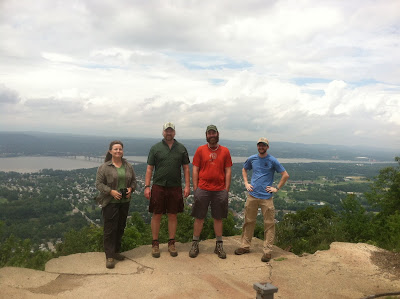
After passing the cottages, the trail reaches the cleared summit area. The first view is to the southeast along the Hudson Highlands. That's followed by a view to the east that encompasses the village of Beacon below you, the Hudson River and the entire Hudson River Valley.
Subscribe to our YouTube Channel so you never miss a hiking video
For those who want more views, there is a fire tower located further back on the mountain that can be reached by following the Casino Trail (red trail) south eastwards for about another 1.2 miles past the vista. For us, after having lunch on the summit, we followed the red Casino Trail down past the former power house for the incline railroad.
This trail is very steep. It loses about 1000 feet of elevation in about eight tenths of a mile (0.80 miles). The trail is highly eroded at the top of the mountain as it makes it way down very steeply. The trail then joins an old road and while it still is climbing (or descending) very quickly, it is not as eroded, there are some switchbacks and is an easier walk. Just before the end of the trail, you reach a series of metal stairs and platforms that have been installed, which provides an easier walking area and some views as you make your way down.

After the steps, you pass the former base station of the railroad and then make your way down on a wide and open trail to the trailhead. At the trailhead there's a large parking lot, restroom facilities an a kiosk offering information on the park and the trails.
Beacon Mountain Hiking Tip!
For those who want to do the up and back hike on Mount Beacon, the Casino Trail is the quickest route up the mountain. The trailhead is also more easily accessible, being right on Route 9, near the village of Beacon and closest to the train station.
Bring plenty of water, where good hiking shoes or boots and expect a workout if you climb Mount Beacon and then descend back down on just the Casino (red) Trail! However you'll be rewarded with a great view.
For the real adventures continue the 1.2 miles past the first mountaintop view to the Fire Tower on top of Mount Beacon, where you will have unobstructed 360-degree views of the Hudson Highlands and the Hudson Valley. That will make for a roughly four mile round-trip hiking from the Route 9D trailhead. You'll be thankful for the extra effort though when you're enjoying the view from the top of the fire tower.

For more information about hiking and exploring around the Village of Beacon and in the Hudson Valley
Beyond the free brochure from Scenic Hudson for the Mount Beacon Park, you can purchase detailed hiking maps from the Trail Conference for the East Hudson Region. This map set includes all of the trails in the Mount Beacon area and is the best resource for those looking to explore the trails of the area. Several books also provide area information for hikes throughout the Hudson Highlands including Best Day Hikes Near New York City, Take a Hike New York City, Weekend Walks in Dutchess and Putnam Counties, and the Explorer's Guide Hudson Valley and Catskill Mountains.
 |
| Look across the highlands |
 |
| Approaching the (main) view to the east |
 |
| Looking across Beacon |
For those who want more views, there is a fire tower located further back on the mountain that can be reached by following the Casino Trail (red trail) south eastwards for about another 1.2 miles past the vista. For us, after having lunch on the summit, we followed the red Casino Trail down past the former power house for the incline railroad.
 |
| The old powerhouse for the incline railroad |
This trail is very steep. It loses about 1000 feet of elevation in about eight tenths of a mile (0.80 miles). The trail is highly eroded at the top of the mountain as it makes it way down very steeply. The trail then joins an old road and while it still is climbing (or descending) very quickly, it is not as eroded, there are some switchbacks and is an easier walk. Just before the end of the trail, you reach a series of metal stairs and platforms that have been installed, which provides an easier walking area and some views as you make your way down.

After the steps, you pass the former base station of the railroad and then make your way down on a wide and open trail to the trailhead. At the trailhead there's a large parking lot, restroom facilities an a kiosk offering information on the park and the trails.
Beacon Mountain Hiking Tip!
For those who want to do the up and back hike on Mount Beacon, the Casino Trail is the quickest route up the mountain. The trailhead is also more easily accessible, being right on Route 9, near the village of Beacon and closest to the train station.
Bring plenty of water, where good hiking shoes or boots and expect a workout if you climb Mount Beacon and then descend back down on just the Casino (red) Trail! However you'll be rewarded with a great view.
For the real adventures continue the 1.2 miles past the first mountaintop view to the Fire Tower on top of Mount Beacon, where you will have unobstructed 360-degree views of the Hudson Highlands and the Hudson Valley. That will make for a roughly four mile round-trip hiking from the Route 9D trailhead. You'll be thankful for the extra effort though when you're enjoying the view from the top of the fire tower.
For more information about hiking and exploring around the Village of Beacon and in the Hudson Valley
Beyond the free brochure from Scenic Hudson for the Mount Beacon Park, you can purchase detailed hiking maps from the Trail Conference for the East Hudson Region. This map set includes all of the trails in the Mount Beacon area and is the best resource for those looking to explore the trails of the area. Several books also provide area information for hikes throughout the Hudson Highlands including Best Day Hikes Near New York City, Take a Hike New York City, Weekend Walks in Dutchess and Putnam Counties, and the Explorer's Guide Hudson Valley and Catskill Mountains.
Advice and Recommended Gear:

Comments
Post a Comment