Advice: Guide to hiking to and visiting Kaaterskill Falls in the Catskill Mountains, NY

The short hike into Kaaterskill Falls, either from the top or the bottom is well worth the effort. You are rewarded with a wild look at one of the most spectacular sights in the Catskills. However both routes while short, pose safety concerns and visitors should be well prepared for their hikes and take plenty of precautions while visiting the area. This is especially important because every year people are injured and some die from accidents that occur while visiting Kaaterskill Falls.
Situated within the Catskill Park and part of New York’s Forest Preserve, Kaaterskill Falls is one of New York's destinations that are forever protected in their natural state by the State’s constitution. Be aware of the natural beauty and resources of this area when visiting and be sure to carry in whatever you carry out and leave the area better than when you found it.
Where is Kaaterskill Falls?
Kaaterskill Falls is located in Kaaterskill Clove along the eastern escarpment of the Catskill Mountains. That makes it about an hour and a half south of Albany and about 3 hours north of New York City. Route 23A climbs through the area from Palenville at the bottom of the mountains to the Hunter-Tannersville-Haines Fall region on top of the mountains. The New York State Thruway is about a 30 minute ride from parking lot on Route 23A. There are two parking areas on Route 23A that provide parking for hikers wishing to visit Kaaterskill Falls from below on the Kaaterskill Falls Trail. From both parking lots there is no dedicated pedestrian walkway, so even access to the Kaaterskill Falls Trail can be dangerous on this narrow, winding mountain road through the clove.
The New York-New Jersey Trail Conference has created a map and guide for the Kaaterskill Falls area that includes the Kaaterskill Falls Trail, the only official route to the falls. The map is available for download on their website or you can download it directly to your smartphone or tablet through the Avenza PDFMaps application. The phone app adds GPS location information and other location based services to the map.
A smidge of history…

The falls themselves were home to the Laurel House Hotel, which was located on top of the falls. You can still see foundation outlines of the old hotel and traces of the well-built trails that brought guests around the falls. There was even a damn upstream of the falls so that once a day – a roaring torrent could be sent over the falls for the guests to watch.
Nowadays the hotels are gone, as are the railroads. All that’s left are slight imprints of the old wonders, including the bridal paths that today form an extensive trail network throughout the area.
If you are looking for more information about the extensive history of this region, we would suggest taking a look at the Catskill Mountain House Trail Guide: In the Footsteps of the Hudson River School (which also doubles as a hiking guide for the area), The Catskills, From Wilderness to Woodstock, or The Catskill Park, Inside the Blue Line.
How do I get to the falls?
There are two major ways to access the falls and both require some level of walking and/or hiking. One is from below the falls and the other accesses the top of the falls. During the 2016 work season, both the top and the bottom areas will be subject to closures as work continues to improve visitor safety and protect natural resources. By the end of 2016 a new trail should connect the top and the bottom of the falls and a new bridge will safely get visitors across the creek above the falls. We have prepared a guide to Kaaterskill Falls Alternatives to help you enjoy the Catskills should you be unable to find parking or access the falls.
From below (via Route 23A)
To access the falls from below, the Kaaterskill Falls Trail runs from the bridge in front of Bastion Falls (a small waterfall adajacent to the roadway) on Route 23A to the base of Kaaterskill Falls.
Parking for the Kaaterskill Falls Trail is located at a parking lot west of Bastion Falls (uphill) or east of Bastion Falls (downhill). Both of these parking lots can get very crowded on weekends and parking is not allowed on the rest of Route 23A. In addition the walk between the parking areas and the official start of the trail at Bastion Falls is along the busy Route 23A so you should exercise extreme caution along this route and its best to avoid having your dog with you because of all the traffic and the potential danger to you and your dog. The road is very narrow, so exercise extreme caution as you make your way to the trailhead.
 The Kaaterskill Falls Trail is well maintained and improved to a point that makes walking general easy and is about a half-mile long (one way). Even though you’ll see people walking in flip-flops and other less than stellar shoes for hiking, you should wear a pair of hiking boots or other sturdy walking shoes (read up on the proper boots). There are many slippery rocks, roots and other obstacles you’ll need to walk around or over. In addition, be sure to bring plenty of water to stay hydrated (learn how to stay hydrated). While short, this trail climbs steeply in several places and you will be thirsty when you reach the base of Kaaterskill Falls and the water in the stream is not safe to drink without proper purification and treatment.
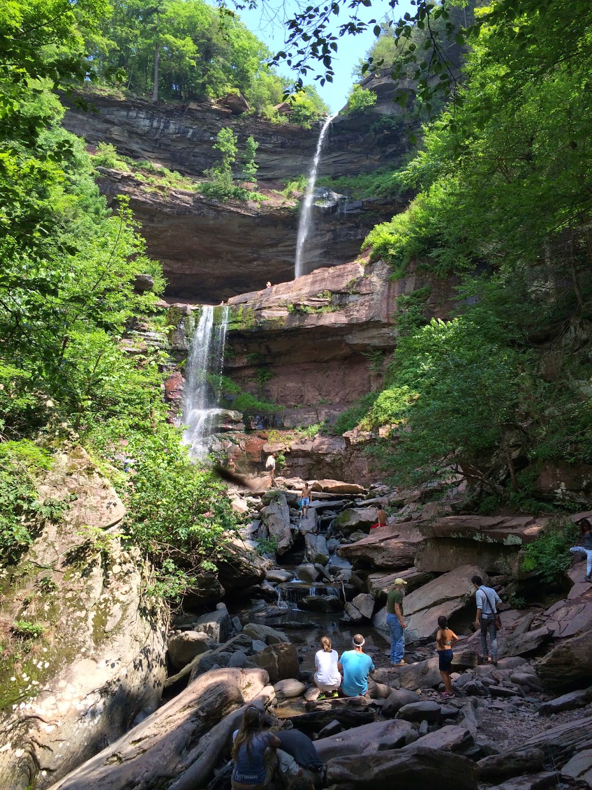
The Kaaterskill Falls Trail takes you to the base of the two-tiered Kaaterskill Falls and ends there. From this vantage point you look up at both tiers of the falls. From here there are no maintained trails and any route you may see to go further is not a safe way to bring you closer to the waterfall, though you will see many people trying to reach higher up around the Falls - that is how accidents and injuries occur.
There are several signs marking the end of the trail at the base of the lower falls and there is also wooden fencing blocking off visitors from traveling further. Rest here and enjoy the view of Kaaterskill Falls, Do Not Go Further!
The NYSDEC is currently building additional trails in the area (as of 2016), but the trails under construction are not open to the public. Visitors should stay on the marked trails and stay off of any partially constructed trails.
Caution – Anything beyond the end of the official trail is dangerous with steep slopes, loose rock, and large drops and in general, it is an area where a mistake could have very bad, if not fatal consequences. DO NOT ATTEMPT TO GO BEYOND THE END OF THE TRAIL. Almost every year someone dies from injuries sustained from falling around the falls.
When you go to return to your car, be sure to carry out any trash that you carry in and leave the area in better condition than you found it since Kaaterskill Falls is one of the most popular destinations in the Catskills and suffers greatly from overuse and litter.
From the top (Via Laurel House Road)

There is no safe way to access the bottom of the falls from the top and I would not suggest attempting to find a way. There are several lines of cliffs and overhangs in the clove and this is an very dangerous area that should be avoided.
The NYSDEC is currently (as of 2016) building a safe connection trail, but until that trail is opened, there is no safe connection. They are also constructing a new pedestrian bridge to safely cross the creek to the north of Kaaterskill Falls (above the falls).
Also at the Laurel House is the entrance to the Kaaterskill Rail Trail. This Rail Trail follows the Ulster and Delaware Railroad grade west from Laurel House Road to the Mountain Top Historical Society campus on Route 23A in Haines Falls. The trip is about 1.5 miles in each direction. A hike along the trail is interesting as you can see how the railroad made its way alongside Kaaterskill Clove and there are glimpses of Kaaterskill Falls from the rail trail itself. For more information on the Kaaterskill Rail Trail, visit the Trail Conference website for it.
Costs?
Beyond the calories you burn to hike to the falls, there are no fees for using the area. The falls are within the forest preserve of the Catskill Park and therefore are open to the public.

Both the top and the bottom of the falls can get very crowded, especially on more popular holiday weekends or during hot weather when people are looking to cool off in the streams.
The bottom of the falls is usually the most crowded – sometimes when you’re hiking the trail you will be in a line of people heading up and be constantly passing people coming down. The top also gets crowded, but the limited views and the lack of a way to get down to the base of the falls keep the crowds slightly thinner.
What can you do?
This is a wild waterfall and beyond the hiking trails there are no improved facilities around the falls. Any activities beyond hiking up to the falls is of your own making and is done on your own. No matter what you do though, make sure you bring a camera to capture some great shots of the falls.
There are swimming opportunities along Kaaterskill Creek as you hike up to the base of the falls. Several smaller falls make deep pools along the creek and are excellent for swimming. People also enjoy standing beneath the falls, though I’d suggest you don’t since you never know if people from up above are throwing trash in the water and you don’t want that to hit you on your head. Some people swim in the pools of Kaaterskill Creek above the falls, but I wouldn’t suggest this, the water is swift and the rocks are slippery and a 180 foot fall isn’t going to feel comfortable.
 You would expect with a 260-foot waterfall that there are plenty of rock climbing opportunities – there are, though you must be adequately prepared for them. A popular activity is to set up rappelling lines off the top of the falls to the top of the lower level – a rappel of about 180 feet. It’s that much more spectacular because after the first few feet at the top, you are rappelling in the open air – there’s nothing around you but the ground below you.
In the wintertime Kaaterskill Falls is home to ice climbers. The falls themselves freeze up in a giant cone and experienced ice climbers can climb on this cone or on the ice flows surrounding the falls on the walls of the clove.
Camping
The North and South Lake State Campground is a few miles down North Lake Road from where you turned onto the Laurel House Road. North Lake is a state run campground that provides maintained sites for tents, trailers and campers and offers activities for campers.
Experiences

All that exploration came in handy when I was an Assistant Forest Ranger in the area for two summers, considering I spent a good part of most weekends in the Kaaterskill Falls area – either making sure there was no illegal camping, or making sure people weren't doing things that were too crazy around the falls (rock climbing in flip-flops comes to mind). I also had the unfortunate task is taking part in several rescues at the falls when people either fell from the falls, or hurt themselves on the steep slopes and cliffs surrounding the falls.
Today working in the Catskills on outdoor recreation in the Catskill Park, Kaaterskill Falls is often an area that I am involved with. This is a beautiful and wild, yet dangerous place to visit and the State, local governments and non-profits are all working together to safeguard the natural resources of the park while providing the safest and most rewarding experience possible for visitors.
I love the falls – even though it’s crowded a lot of the time. It’s just a spectacular area that continues to amaze me every time I’m there, even though I've already spent so much time there.
One of my most favorite things to do is to climb the trail to the base of the falls after a heavy rain. Most of the year the water coming over the falls is merely the flow of a small stream, after a heavy rain or flooding event, Kaaterskill Creek is a seething, boiling, river of red water (Catskill mud is red). When you’re standing near the falls you can hear the rocks tumbling over the falls and you can actually smell the rocks grinding against one another. It’s really an incredible experience.
Final Thoughts…
Most people will be able to hike either trail, but exploring the falls themselves beyond the trails is best left to people with extensive hiking and climbing experience. The falls can and are dangerous, don’t put yourself in a situation where you are going to be the one who needs to be rescued.
Whether it’s just the hike and the view your after, the ice climbing potential in the winter, the chance to see a big waterfall up close, or a chance to swim in a clear and cold mountain stream, Kaaterskill Falls offers a lot to any visitor who’s looking to find one of nature’s wonders.
Need more information on hiking and planning your
trips to the Catskills and the Catskill Park?
Read up on the Catskill Park at our Catskill Mountains Information Page for hikes, advice, travel and planning information. We have a Guide to Hiking in the Catskills available and on our sister site, ReviewThis is a Guide to visiting the Catskill Park.
Need a hiking map for your hikes in the Catskills? We recommend the Trail Conference's Catskills Trails 6-Map Set
How about a guidebook? Both AMC
If you are looking for more information about the extensive history of the Catskill Mountains and the Catskill Park, we would suggest reading The Catskills, From Wilderness to Woodstock and The Catskill Park, Inside the Blue Line. For the most comprehensive natural history of the Catskill Park and the Forests of the Catskill region, we recommend reading The Catskill Forest, a History by Michael Kudish.


Comments
Post a Comment