Hiking: Catskills Frick Pond Loop via Quick Lake, Big Rock and Loggers Loop Trails | Southwestern Catskill Mountains, NY
.JPG)
The Frick Pond loop hike, completed by traveling on the Quick Lake Trail, the Big Rock Trail and the Loggers Loop Trail is an easy, pleasant 2.2 mile (round trip) hike. Along the way you cross the outlet of Frick Pond where there are great views of the pond and the surrounding mountains, walk through a large hemlock grove, follow an extensive boardwalk through a swampy area, cross the two major inlets to Frick Pond and then make your way back through open woods and fields of ferns.
Getting There - Quick Lake and Flynn Trail Trailhead

 The Quick Lake/Flynn Trail Trailhead is located near the end of Beech Mountain Road. To reach the trailhead, follow Debruce Road east from Livingston Manor (Exit 96 on Route 17) for just under 6 miles (5.8) to the intersection with Mongaup Road. Turn left onto Mongaup Road and follow it for about 2.7 miles to its intersection with Beech Mountain Road. Bear to the left onto Beech Mountain Road, which quickly become a dirt road. Follow Beech Mountain Road for about a third of a mile and the trailhead parking area will be located on your left just after the road climbs up a hill. The road ends just above this point at a private residence.
While the Flynn Trail heads northward from the east side of Beech Mountain Road (eventually making its way to Hodge Pond) across the street from the trailhead parking area, the Quick Lake Trail starts at the northwestern corner of the trailhead parking area and travels westward towards Frick Pond. The trail's start is not signed, but it descends from the northwestern corner on several wooden steps and then begins makings its way through the forest.
The trails in this area are shown on the Trail Conference's Western Catskill Trails map (#144), which can be purchased as part of the 6-map set on tyvek or purchased individually on your smartphone or tablet. These trails are also shown on the National Geographic's Trails Illustrated Catskills Map. They are described in the AMC's Catskill Mountain Guide and the ADK's Catskill Trails guidebooks.
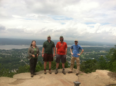
.JPG) The Hike
The HikeFrom the northwestern corner of the parking lot, the red marked Quick Lake Trail descends on several log steps and then travels, on a mostly level route through the open hardwood forest. In about a tenth of a mile (0.10 miles), the trail intersects with an old road that used to provide access to Frick Pond. There is a DEC sign-in booth at this intersection (make sure to sign in) and the trail turns left and follows the road from this point to the trail's intersection with the Loggers Loop Trail. The old road is wet in several places, especially during the spring. The road is generally level with a few dips and climbs past streams and drainages. At just under a half of a mile (0.45 miles), the Quick Lake Trail intersects with the yellow marked Loggers Loop Trail. The intersection is located within an old field that can become overgrown and be poorly signed. Be sure to stay to the left at the intersection, on the Quick Lake Trail.
.JPG) The Quick Lake Trail passes through another muddy area just past the trail junction and then begins descending to shoreline and outlet of Frick Pond at about 0.55 miles from the trailhead (and about a tenth of a mile from the intersection with the Loggers Loop Trail). The bridge and the small open field adjacent to it make for a great stop to enjoy the view of Frick Pond and watch the wildlife who live there. The dam on Frick Pond was removed (or destroyed) many years ago so the actual water body is quite small during most of the season, but due to high spring water, the pond has remained an open meadow and provides habitat for a number of wildlife species, including a number of different birds.
The Quick Lake Trail passes through another muddy area just past the trail junction and then begins descending to shoreline and outlet of Frick Pond at about 0.55 miles from the trailhead (and about a tenth of a mile from the intersection with the Loggers Loop Trail). The bridge and the small open field adjacent to it make for a great stop to enjoy the view of Frick Pond and watch the wildlife who live there. The dam on Frick Pond was removed (or destroyed) many years ago so the actual water body is quite small during most of the season, but due to high spring water, the pond has remained an open meadow and provides habitat for a number of wildlife species, including a number of different birds.After crossing the outlet of Frick Pond on a bridge, the trail generally follows the shoreline of Frick Pond, but back from the edge. The trail has a few minor wet areas and is generally level as it heads towards the intersection with the Big Rock Trail. At this trail junction, the Quick Lake Trail turns westward, eventually reaching Quick Lake and the Quick Lake Lean-to and the Big Rock Trail continues to follow the shoreline of Frick Pond. At this point, make sure to stay to the right and follow the yellow marked Big Rock Trail.
.JPG)
Stay to the right and head south on the Loggers Loop Trail. This former woods road is wet in several places, but a generally dry treadway has developed to avoid the majority of the muddy areas. This section of trail also travels through open woods and the road itself is a mix of meadow grasses and ferns (in the more shaded areas). This plant life can grow quickly during the summer, making the trail overgrown in places at times.
.JPG) From Times Square, the yellow marked Loggers Loop trail descends slightly, crossing a small stream on a washed out culvert and then begins gently ascending to the height of land after about two tenths of a mile. Once the height of land is reached, the trail is generally level for another two tenths of a mile before beginning to descend slightly. As views of Frick Pond begin to open up and just before the trail's intersection with the Quick Lake Trail, there is a privy to your right on a short side trail.
From Times Square, the yellow marked Loggers Loop trail descends slightly, crossing a small stream on a washed out culvert and then begins gently ascending to the height of land after about two tenths of a mile. Once the height of land is reached, the trail is generally level for another two tenths of a mile before beginning to descend slightly. As views of Frick Pond begin to open up and just before the trail's intersection with the Quick Lake Trail, there is a privy to your right on a short side trail. The trail then comes to an end at its intersection with the Quick Lake Trail at 0.55 miles. This trail junction is the first trail junction you reached when following the Quick Lake Trail from the Beech Mountain Road trailhead parking area. At the trail junction, turn left onto the red marked Quick Lake Trail, heading eastward towards the trailhead. Follow this section of the Quick Lake Trail for 0.45 miles to return to the trailhead and complete your hike.
There are no difficult sections along this hike and no steep climbs or descents. The most difficult aspects of the hike are the numerous wet areas, especially near Times Square on both the Big Rock and the Loggers Loop Trail. If you don't mind getting your boots muddy though, this is not a problem. Trail maintenance is picking up in the area, thanks to the Trail Conference's Willowemoc Trail Crew. This trip is a great hike for families with children looking to spend a few hours in the woods. It's close to the Mongaup Pond State Campground and the Town of Livingston Manor is less than 8 miles away. In Livingston Manor there's lodging and dining options, along with Morgan Outdoors, a great outdoor clothing, shoes and gear store that's an excellent place to get ready for your adventures. The owner of the store is a great resource to ask for information on trails, hikes and how to get involved with stewardship activities in the area.
This is one of my favorite hikes in the Catskills because it's such a pleasant and accessible walk for everyone (especially during the summer when the majority of the wet areas dry up). With the upcoming work by the Willowemoc Trail Crew, this hike will only get better (and drier).
Watch all of our videos about hikes in the Catskills on YouTube
Need more information on hiking and planning your
trips to the Catskills and the Catskill Park?
Read up on the Catskill Park at our Catskill Mountains Information Page for hikes, advice, travel and planning information. We have a Guide to Hiking in the Catskills available and on our sister site, ReviewThis is a Guide to visiting the Catskill Park.
Need a hiking map for your hikes in the Catskills? We recommend the Trail Conference's Catskills Trails 6-Map Set
How about a guidebook? Both AMC and ADK
 publish trail guides to the Catskill Region and the Adventures in the Outdoors Bookstore carries many more books and maps that will help you as you hike and explore the Catskill Mountains region.
If you are looking for more information about the extensive history of the Catskill Mountains and the Catskill Park, we would suggest reading The Catskills, From Wilderness to Woodstock and The Catskill Park, Inside the Blue Line. For the most comprehensive natural history of the Catskill Park and the Forests of the Catskill region, we recommend reading The Catskill Forest, a History by Michael Kudish.


Comments
Post a Comment