Hiking: Huggins Pond | Catskill Mountains, NY | May 2007
For someone who has spent most of his years in the northeastern Catskills, Huggins Pond located in Delaware County near the Pepacton Reservoir is like the other side of the world. Hell, just getting there is an expedition.
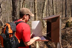
The trail to Huggins Pond isn’t an official trail, instead it’s a roadway that’s maintained by the DEC in order to reach the Pond so that it can be stocked and the fishery managed. Though there is a sign-in register and a trail sign for hikers, there’s just no markers on the way to the lake.
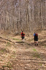
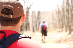
 The trail is a rather pleasant (and fairly easy) walk up over the height of land and then back down to the lake, which isn’t as far down on the other side of the ridge. The road is wide and easy to follow and while there really aren’t any views, I enjoyed the walk.
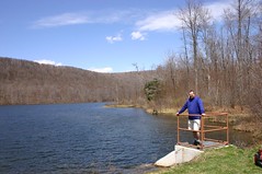
 Huggins Pond is pretty unassuming. It’s nestled along the shoulder of the ridge and from where you come out on the dam, the lake stretches back towards the ridge and curves towards the right.
The nicest part of the hike is stopping on the dam or the adjacent grassy area, lying out and having a nice lunch in the sunshine while taking in the view of the lake.

Read up on the Catskill Park at our Catskill Mountains Information Page for hikes, advice, travel and planning information. We have a Guide to Hiking in the Catskills available.
Need a hiking map for your hikes in the Catskills? We recommend the Trail Conference's Catskills Trails 6-Map Set . These maps are the best available for hiking and outdoor adventures in the Catskills and the Catskill Park. The Catskill Center offers a regional map of the Catskills that provides an excellent overview of the region, it's roadways, attractions and trails. National Geographic Trails Illustrated also produces a map for the region that is useful for trip planning and road navigation. How about a guidebook? Both AMC
 and ADK
 publish trail guides to the Catskill Region .
If you are looking for more information about the extensive history of the Catskill Mountains and the Catskill Park, we would suggest reading one of the following: The Catskills, From Wilderness to Woodstock; The Catskill Park, Inside the Blue Line; or The Catskills, It's History and how it changed America. For the most comprehensive natural history of the Catskill Park and the Forests of the Catskill region, we recommend reading The Catskill Forest, a History by Michael Kudish.


The trail to Huggins Pond isn’t an official trail, instead it’s a roadway that’s maintained by the DEC in order to reach the Pond so that it can be stocked and the fishery managed. Though there is a sign-in register and a trail sign for hikers, there’s just no markers on the way to the lake.
The nicest part of the hike is stopping on the dam or the adjacent grassy area, lying out and having a nice lunch in the sunshine while taking in the view of the lake.
MORE CATSKILL PARK, HIKING, PLANNING AND VISITOR INFO
Read up on the Catskill Park at our Catskill Mountains Information Page for hikes, advice, travel and planning information. We have a Guide to Hiking in the Catskills available.
Need a hiking map for your hikes in the Catskills? We recommend the Trail Conference's Catskills Trails 6-Map Set
If you are looking for more information about the extensive history of the Catskill Mountains and the Catskill Park, we would suggest reading one of the following: The Catskills, From Wilderness to Woodstock; The Catskill Park, Inside the Blue Line; or The Catskills, It's History and how it changed America. For the most comprehensive natural history of the Catskill Park and the Forests of the Catskill region, we recommend reading The Catskill Forest, a History by Michael Kudish.


I've been going to Huggins Lake for years. It used to be a Boy Scout Camp named Indian Ridge. It was owned by the now defunct Camden County Council in NJ. During the gas crisis of the 70's it became too expensive to get to so they sold (presumably to one of the Rockefellers). Later it ended up in the hands of the State of NY.
ReplyDeleteI too use to camp there. I was there as a scout and went back years later as a young adult. There is a rock the size of a house we called Lookout Rock. Some friends and I use to maintain a marked trail to the rock but we have not been there in 10 years. The trail starts at the edge of the lake at the opposite end of the dam.
ReplyDeleteI have a lot of fond memories of Indian Ridge and Huggins Lake. There were several campsites bordering the outfall stream. There was an L-shaped dock at the lake. The water was damned cold, but scouts did not seem to mind...only the adults did. I remember being inducted into the OA in a "Tap-out" ceremony where inductees names were called out, then they were canoed across the lake to a large tepee. In addition to the trail to Lookout Point (I remember camping out overnight under the stars on the large rockledge, there were other trails. One went down to the Beaver Kill, and ultimately to Onteora Scout Camp. Another encircled the camp from Lookout Point to the east of the camp, bringing you back from the south (I do not remember all the particulars). I remember making a plaster model (with others) of the relief of the camp based on a contour map. I remember the stars at night. WOW. Too bad camden County Council did not have the wherewithal to keep Indian Ridge. My understanding is that NYS regulations were too much to overcome. Now it is part of the Catskill Forest Preserve, state owned land.
ReplyDeleteWhat the internet is best at! I'd been trying to figure out where Indian Ridge was, I went to camp here in 1971. The bus dropped us off at the road and we had to carry our packs into camp. My 11 year old eyes saw this as a 10 mile long hike up a towering mountain that nearly killed me. Makes me laugh to see it was a 1 mile walk with 400 foot gain. It is nice to know I can do this much better at age 55 than I could at age 11!
ReplyDeleteI was on staff at Indian Ridge in 1972. Gasoline prices may have contributed to closing the camp, but the nail in the coffin was a change in New York state regulations for children's camps that required flush toilets. The camp used latrines for each campsite that were built directly over a septic tank. the commodes dropped directly into the tank. Potable water was available to each site from an electric pumped well just uphill from the dam and distributed to the sites and a single shower station by black plastic pipe laid on the ground. The was a galvanized steel trough at each latrine as well as flush urinals that drained into the septic tank.
ReplyDeleteI camped there in the late '60's, '68 & '69 I think. At that time it was really primitive. As I remember, there were no permanent/semi-permanent structures. The cooler for food was the only thing even remotely resembling a structure and it was just a single room, like a restaurant walk in cooler in the middle of one of the fields. Staff stayed in the same tents as the Boy Scouts. The "Shower House" was a tank, painted black supported by two cinder block walls on each end with about 6 shower heads on both sides of the tank. Talk about cold, no hot water at all! Only bushes for screening and privacy. Troop youth and leaders showered together all at once. Today would have been a YPT nightmare!
ReplyDeleteI, too camped there as a Boy Scout in 1980 & 1981. At that time, the property "Indian Ridge" was still owned by Camden County Council, but did not operate as a camp. My troop, 117/123 (Runnemede, NJ) received permission from the Council to hold summer camp there. At that time, Huggins Pond Rd was in rough shape. The dock was still there, as was the orienteering tower adjacent to the dock. Also, the refer was there, as was the flagpole as well as a reach in freezer which one of the men got to work via a portable generator! We hiked to lookout point, hike down the River to a waterfall. The campsite latrines were still there.
ReplyDeleteAround 1990, 3 of my fellow troop member & I went back for a weekend camping trip. It was great to go back & I will again one day soon.