Platte Clove Preserve Trail - Catskill Mountains, NY - 5/22/11
Another work related hike, but it was a good chance to get the Maisy out for a hike since she's been cooped up with all the bad weather we've been having (and continue to have). While it wasn't great hiking weather (50s, pea soup fog and drizzle), I did need to get out there to scout for some trail work that I'll be organizing in the near future.
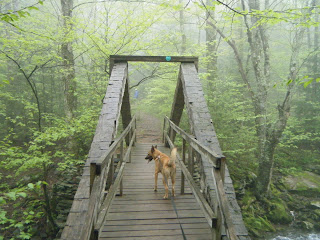
The trail starts from a small parking area alongside Platte Clove Road at the Platte Clove Preserve (a larger lot is located just to the east on Platte Clove Road - head east about 2 tenths of a mile and turn onto the dirt road with the trailhead sign. Just up the hill is a large lot with plenty of parking) and drops down to Plattekill Creek and crosses it on a replica of the kingspost bridge that the original, Overlook Road used. This smaller sized replica was built by volunteers from the NYNJ Trail Conference several years ago.
The trail from the bridge climbs the hill steadily as its makes its way around small streams and through the dense hemlock forest. It passes a few small bluestone quarries before rejoining with the original Overlook Road, where it quickly crosses into the State Forest Preserve lands. From there, the trail continues to an intersection with the trail from the Prediger Road trailhead and just beyond is another intersection, this time with the Indian Head Trail. The Devil's Kitchen Lean-to is just beyond that intersection.
We only walked to the intersection with the old road, which was about a half of a mile. Maisy enjoyed the fresh air and I was able to scout out some trail improvements that will get done this summer.
Trip Details
NYNJTC Catskill Trails Map #141
Mileage - about half a mile

Need a hiking map for your hikes in the Catskills? We recommend the Trail Conference's Catskills Trails 6-Map Set. These maps are the best available for hiking and outdoor adventures in the Catskills and the Catskill Park. The Catskill Center offers a regional map of the Catskills that provides an excellent overview of the region, it's roadways, attractions and trails. National Geographic Trails Illustrated also produces a map for the region.


The trail starts from a small parking area alongside Platte Clove Road at the Platte Clove Preserve (a larger lot is located just to the east on Platte Clove Road - head east about 2 tenths of a mile and turn onto the dirt road with the trailhead sign. Just up the hill is a large lot with plenty of parking) and drops down to Plattekill Creek and crosses it on a replica of the kingspost bridge that the original, Overlook Road used. This smaller sized replica was built by volunteers from the NYNJ Trail Conference several years ago.
The trail from the bridge climbs the hill steadily as its makes its way around small streams and through the dense hemlock forest. It passes a few small bluestone quarries before rejoining with the original Overlook Road, where it quickly crosses into the State Forest Preserve lands. From there, the trail continues to an intersection with the trail from the Prediger Road trailhead and just beyond is another intersection, this time with the Indian Head Trail. The Devil's Kitchen Lean-to is just beyond that intersection.
We only walked to the intersection with the old road, which was about a half of a mile. Maisy enjoyed the fresh air and I was able to scout out some trail improvements that will get done this summer.
Trip Details
NYNJTC Catskill Trails Map #141
Mileage - about half a mile
Need more information on hiking and planning your
trips to the Catskills and the Catskill Park?
Read up on the Catskill Park at our Catskill Mountains Information Page for hikes, advice, travel and planning information. We have a Guide to Hiking in the Catskills available and on our sister site, ReviewThis is a Guide to visiting the Catskill Park.
Need a hiking map for your hikes in the Catskills? We recommend the Trail Conference's Catskills Trails 6-Map Set
How about a guidebook? Both AMC and ADK
 publish trail guides to the Catskill Region and the Adventures in the Outdoors Bookstore carries many more books and maps that will help you as you hike and explore the Catskill Mountains region.
If you are looking for more information about the extensive history of the Catskill Mountains and the Catskill Park, we would suggest reading The Catskills, From Wilderness to Woodstock and The Catskill Park, Inside the Blue Line. For the most comprehensive natural history of the Catskill Park and the Forests of the Catskill region, we recommend reading The Catskill Forest, a History by Michael Kudish.


Comments
Post a Comment