Hiking: Resupply hike for Backcountry Trail Crew building new section of Long Path on Romer, Pleasant and Cross Mountains | Catskill Mountains, NY | June 4, 2013
 |
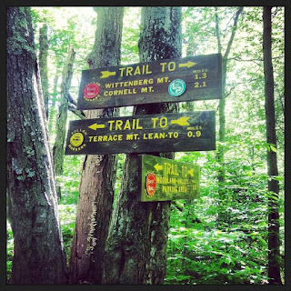
| At the trail junction of the Wittenberg-Cornell-Slide Trail and the Terrace Mountain Trail |
Getting to the WCS Trail
The Wittenberg-Cornell-Slide Trail (also known as the Burroughs Range Trail) leaves from the Woodland Valley Day Use Parking area near the end of Woodland Valley Road about 8 miles from the Village of Phoenicia. Access is from Route 28, then Woodland Valley Road. You must pay a day use fee for the parking area when the campground is open. This area is shown on Trail Conference Map #143.
Hiking
With a backpack that was significantly heavier than I'm used to thanks to all the crew supplies, I made the trip up the WCS Trail between the parking area and just past its intersection with the Terrace Mountain Trail. From there I went cross country and bushwhacked out to our crew's camp.
From the parking area, the WCS Trail crosses Woodland Valley Road, heads north (downhill) along the road for about 100 feet and then turns to the right and passes through campsites of the Woodland Valley Campground. The trail then crosses the Woodland Valley Creek on a foot bridge. After the bridge the trail begins climbing steeply. At about a tenth of a mile in, the trail passes a Trail Register. Make sure to register, as Rangers use this information during search and rescues and the DEC uses it to measure use on trails. Beyond the register the trail continues to climb steeply for about three quarters a mile.
A final switchback marks the change from a steep climb up the flank of the ridge to a more gently climb on the crest of the ridge. There are a few limited views (especially in the wintertime) along the way and in a few places the trail comes to somewhat open ledges. Once you have reached the crest of the ridge, the trail follows an easier route along the northwestern shoulder of Wittenberg Mountain. The trail crosses several seasonal streams and generally follows the edge of the ridge, first climbing southeast and then more easterly towards the trail junction with the Terrace Mountain Trail.
 |
| Resting up after dropping off supplies for the Backcountry Trail Crew |
At 2.6 miles from the Woodland Valley Campground, the trail comes to the junction with the Terrace Mountain Trail. The Terrace Mountain Trail travels 0.9 miles northward to the Terrace Mountain Lean-to and several vistas. The trail is a dead-end trail at the lean-to though, so you will have to hike back out to the WCS Trail to descend back down to Woodland Valley.
The Terrace Mountain Trail follows an old road that climbed the mountain from Woodland Valley and then
continued up past the intersection with the WCS Trail so at the trail junction, the WCS begins following the old road and continues ascending at a moderate pace before it turns and then climbs steeply up the flanks of Wittenberg to the summit.
I turned off along the way to reach the camp, which was about another 3/4 of a mile or so from the WCS trail and then descended back down to Woodland Valley when I was done.
It took me about 2 hours to reach the Terrace Mountain/WCS trail junction and just over an hour to get back down from the trail junction. Was a great day weatherwise for this strenuous hike.
Trip Details
5.2 miles round trip (to the WCS/Terrace Mountain Trail intersection)
1200 foot elevation climb (and descent)
Trails shown on Map #143 of Catskill Trails Map Set
Check out the 2nd resupply hike for the Trail Crew where I got further down the ridge and got some photos from what will probably be the best view along the entire new trail.
For More Information on Hiking and the Outdoors in the Catskill Mountains
Check out our Catskill Mountain Information Page for hikes, advice and planning information.
Need a hiking map for the Catskills? The Trail Conference publishes the Catskills Trails Map 6-map Set , which is the best set of maps available for hiking in the Catskills.
  How about a guidebook? Both AMC
 and ADK
 publish Trail Guides to the Catskill Region and the Adventures in the Outdoors Bookstore carries many more books and maps for hiking and exploring the Catskill Mountain region.
Need a hiking map for the Catskills? The Trail Conference publishes the Catskills Trails Map 6-map Set

Comments
Post a Comment