Hiking: Mount Pemigewasset (Indian Head) via Mt. Pemigewasset Trail | White Mountains, New Hampshire | 5/18/2014


A note of caution, these ledges are very high with a large drop off and they do sort of come upon your quickly as you make your way to the summit from the Indian Head/Mt. Pemigewasset Trail Junction. If you have a dog with you or small children, you might want to keep them close as you make your way to the summit. The open rocks were not slippery at all when we were there as it was dry, but it wet conditions, there is more potential for someone to slip and fall on the wet ledges.
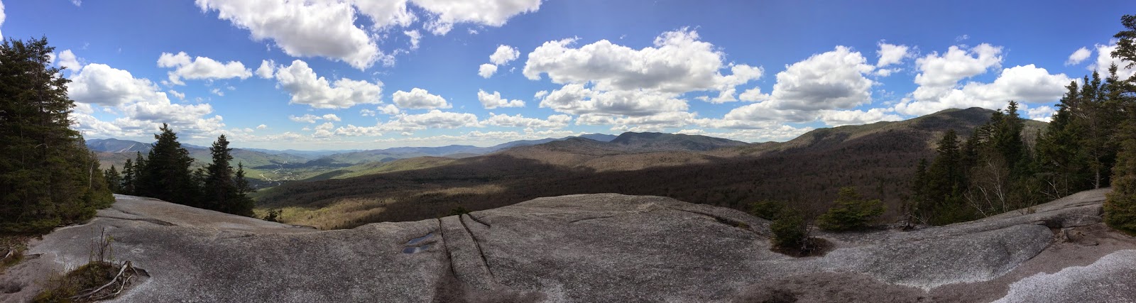
That said, you will be well rewarded for the climb up Mount Pemigewasset at this series of rock ledges. They rise significantly above the treeline below and offer unobstructed vistas of the country beyond.

The true summit of Mount Pemigewasset is a little further east, but the trees surrounding the true summits ledges have grown up significantly and blocked out a lot of the view. From the summit there are some views of the Franconia Range northeast, but the major views are from the first set of open rock ledges you reach. Those ledges offer an extensive view to the south, southwest and west, offering views down into the Lakes Region and along the Kinsman Ridge.
We ended up spending the sunny afternoon having lunch and just relaxing on the summit. It was one of the first warm spring days and it was the kind of place that was perfect to sit back and let it all soak in.


Only downside to this hike is that it given its location and moderate difficulty, the hike is very popular with people who are visiting Franconia Notch. Don't got on a weekend expecting to find an empty peak!
Otherwise a great hike that is not that difficult with a tremendous view. If you just have a few hours in the Franconia Notch area, this hike is a great choice that you won't be disappointed in.
###
Watch all of our videos about hikes in the New Hampshire on YouTube
Sign up for our newsletter for regular hike info, gear reviews, videos, and more!
You can find this hike:Outdoor Hiking, Backpacking and Camping Guide Services:
Advice and Recommended Gear:
Thanks for watching! Be sure to like and subscribe on YouTube if you enjoyed our video. We appreciate the opportunity to share our adventures with you and highlight members of the LGBTQ+ community enjoying the outdoors. Proud gay hikers here! Find out more about us at The Hiker Trash Husbands on the web - https://www.hikertrashhusbands.com
- Weather: Check the weather forecast before your hike and be prepared for changes in conditions. Weather can be unpredictable, so bring appropriate clothing and gear.
- Safety: Some sections of the trail can be steep and rocky, so use caution and watch your footing. It's also a good idea to hike with a friend or let someone know about your hiking plans.
- Leave No Trace: As with any outdoor activity, remember to follow the principles of Leave No Trace. Pack out any trash, stay on the trail, and be respectful of the natural environment.


Comments
Post a Comment