Hiking: Devil's Path Challenge, Catskill Mountains, NY
 |
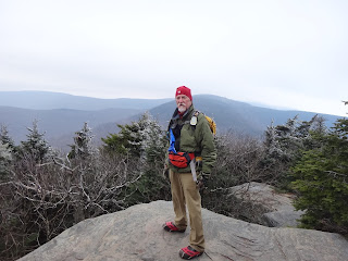
| The author on the south summit of Twin Mountain |
- INDIAN HEAD - November 24, 2015
- TWIN MOUNTAIN – December 9, 2015
Twin Mountain: We spotted one vehicle at the Roaring Kill Trail Head (TH), for when we finished the hike. We took the second vehicle to the Prediger Road TH, where we started the hike up the Jimmy Dolan Notch Trail. We had decided to go up this way, because it was a lot tougher than the Pecoy Notch trail we would use going out, when we would be more tired.
The temp was in the mid 30’s, low 40’s, and stayed that the rest of the day. We were on the trail at 9:10 AM at an altitude of 2056’, and went up one of the rockiest trails in the Catskills. Steady climbing for 1100’, with the steepest part in the last ½ mile. We were at the notch at 11 AM. We turned north to ascend the South Summit of Twin Mountain. Very rocky terrain, with a number of ledges. We climbed the 400’ to the South Summit at 3565’, arriving at 12 Noon.
We stayed for a few minutes then continued on the ridge trail to the North Summit. The wind had picked up to what we felt was about 25mph, with stronger gusts. We had lunch along the trail, which was wooded, so we were out of the wind. The trail was nice & mostly even, with some areas where we had to climb up rocky parts. There is a huge cave between the summits, perfect for a hibernating bear. Hal was ahead, and just as I passed the cave, I heard a low growl, which startled me. Hal had only cleared his throat, which was a relief.
We arrived at the North Summit of 3642’ at 1 PM, and after taking a few pictures we intended to head down the ½ mile to Pecoy Notch. That was we made the mistake of not heading down, but started back on the same trail to the South Summit. We didn’t recognize anything, because we were heading in the opposite direction. We got to an open rock, where NUDE=FREE scratched, which Hal recognized, and in a few more steps realized we were back at the South Summit. We knew we had to retrace our steps, but the extra 1.4 miles round trip, had cost us a lot of time. It was 2:30 PM, by the time we got back to the North Summit, and found the right trail.
This started the steepest part of the hike, in only 1/2 mile we descended 600’. One section of 25’ or so we had to use a rope to get us down. We didn’t see how this could be the trail, but we couldn’t find an alternative. We found the trail marker right after the descent. There a number of other rocky clefts, and steep ledges that had to be maneuvered but the rope wasn’t necessary.
We got down to Pecoy Notch at 4 PM, when it was starting to get dark. We moved quickly down. Arriving at Dibbles Quarry we had to don head lamps to continue back to the trailhead. Luckily we had decided to go down this way, as going down the way we came up in the dark would have been torture.
We were out at 5:45 PM in total darkness, after what was one very tough hike. The hike was very satisfying, and we had gotten out safe & sound.Later than we had anticipated, but it proved you have to be prepared. 8:45 hours on the trail. 7 ½ miles total, including the backtracking.
- Ascent 2251’ to a max of 3656’
- Descent 2322’ to a minimum of 1959’
Stay tuned for the trip over Indian Head Mountain!
Welcome Alan to Adventures in the Outdoors as our newest contributor! Alan is a member of the Catskill 3500 Club, and the Rip Van Winkle Hiking Club (RIP's). He leads intermediate hikes for the RIP's, and alternate weeks do other mostly more challenging hikes with a close group of friends who are all retired, and hike on Wednesday's to avoid the crowds on the trails. Alan is 72 years old and started doing the 35 Catskill Peaks in 2009 at 65. I finished the requirements for the 3500' Club membership in 2012 at 69. Alan has 16 Winter Peaks done, and plans to work on more this winter.
Need more information on hiking and planning your
trips to the Catskills and the Catskill Park?
Read up on the Catskill Park at our Catskill Mountains Information Page for hikes, advice, travel and planning information. We have a Guide to Hiking in the Catskills available and on our sister site, ReviewThis is a Guide to visiting the Catskill Park.
Need a hiking map for your hikes in the Catskills? We recommend the Trail Conference's Catskills Trails 6-Map Set
How about a guidebook? Both AMC and ADK
 publish trail guides to the Catskill Region and the Adventures in the Outdoors Bookstore carries many more books and maps that will help you as you hike and explore the Catskill Mountains region.
If you are looking for more information about the extensive history of the Catskill Mountains and the Catskill Park, we would suggest reading The Catskills, From Wilderness to Woodstock and The Catskill Park, Inside the Blue Line. For the most comprehensive natural history of the Catskill Park and the Forests of the Catskill region, we recommend reading The Catskill Forest, a History by Michael Kudish.


Comments
Post a Comment