Hiking: Early Snowshoe Hike | Hunter Mountain and Southwest Hunter Mountain, Catskill Park, NY | November 23, 2018
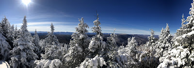
For Black Friday 2018, we decided to #OptOutside and avoid the crowds and craziness of the malls and other retail outlets. What a good choice it turned out to be as we were rewarded with incredible views and amazing early winter conditions on the summits of Hunter Mountain and Southwest Hunter Mountain.


One of the best loop hikes in the Catskills, this trip covers just over 10 miles and climbs over the summits of Hunter Mountain and Southwest Hunter Mountain, which are both peaks that exceed 3500 feet in elevation. Hunter Mountain is the second highest in the Catskills at 4030 feet in elevation.
I've always found doing the loop in a clockwise fashion is the most rewarding, but the loop could be done in either direction without much change in difficulty or time required. For us, we began at the Spruceton Trail Trailhead just off of Spruceton Road. The Spruceton Trail is the jeep road that is used to access the Hunter Mountain Fire Tower and therefore is a moderate hike on a well maintained trail/jeep road. On our visit there was several inches of snow on the ground at the base and we put our snowshoes right off the bat. It was also an abnormally cold November day with a temperature that hovered around 0 for most of the day. Together it added up to create an early season winter wonderland to hike through.
After reaching the summit and the Fire Tower, follow the Hunter Mountain Trail as is slowly descends first to the trail junction with the Becker Hollow Trail and then down to the Devil's Acre Lean-to. We stopped for lunch at the lean-to, but given the cold temperatures, we didn't hang out too long before we started going again. From the lean-to, we started off on the Devil's Path towards the Spruceton Valley. After a few tenths of a mile, we turned off to the left on the old railroad grade that takes you to the route to Southwest Hunter's summit. This 2 mile round trip in and back trip isn't difficult, but there are a few short steep sections between the railroad grade and the summit of Southwest Hunter.
Once we got back to the Devil's Path after climbing Southwest Hunter, we headed down on the Devil's Path to Diamond Notch and then out the Diamond Notch Trail to Spruceton Road and then a short walk down the road back to the Spruceton Trail Trailhead.
All in all, 10.3 miles and 2,297 feet of elevation gain (and loss). A great hike in any kind of weather, but really nice in this case because of the incredibly clear skies, deep snows and amazing views and scenes as we made our way up and down.


Trail(s) Description:
- Difficulty: Moderate/Difficult
- Length: 10.3 Miles
- Elevation Gain: 2,297 feet
- Map & Guidebook: Catskill Trails by NYNJ Trail Conference / Catskill Mountains Guide by AMC
Begin on the Spruceton Trail at the Spruceton Trail Trailhead on Spruceton Road. Follow the trail (which is a jeep trail that is moderately graded and well maintained) 1.7 miles to the notch between Rusk Mountain and Hunter Mountain. From this notch, the trail becomes narrower and begins climbing more steeply up Hunter Mountain (while continuing to be a jeep trail). After 0.7 miles you'll reach the side trail to the John Robb Lean-to and then shortly thereafter the intersection with the Colonel's Chair Trail. Continue on the Spruceton Trail another mile to the summit of Hunter Mountain, where the Hunter Mountain Fire Tower is located.
From the summit, follow the Hunter Mountain Trail first, 0.3 miles to the intersection with the Becker Hollow Trail and then 1.35 miles to the Devil's Acre Lean-to and the intersection with the Devil's Path just before the lean-to.
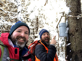
After the lean-to, stay on the Devil's Path and head west towards Diamond Notch. After about .02 miles, you'll see a faint path heading to the left that follows a former railroad grade. Follow the grade for about 0.75 miles to where you take a hard left (a small cairn usually marks the site) and then continue up to the summit of Southwest Hunter, where one of the Catskill 3500 Club canisters is located. Return the way you came to the Devil's Path.
Follow the Devil's Path for about 1.3 miles as it descends to Diamond Notch. Upon reaching the Diamond Notch Trail, pass by Diamond Notch Falls and continue heading downstream (downhill) on the Diamond Notch Trail for just under a mile. You'll reach the end of Spruceton Road. Walk on Spruceton for a few tenths of a mile to reach the Spruceton Trail Trailhead.
Watch all of our videos about hikes in the Catskills on YouTube
Sign up for our newsletter for regular hike info, gear reviews, videos, and more!
You can find more information about this hike on:
Find additional information about the Catskill Park by visiting the Catskills Visitor Center
Outdoor Hiking, Backpacking and Camping Guide Services:
Outdoor Hiking, Backpacking and Camping Guide Services:
Advice and Recommended Gear:
Thanks for watching! Be sure to like and subscribe on YouTube if you enjoyed our video. We appreciate the opportunity to share our adventures with you and highlight members of the LGBTQ+ community enjoying the outdoors. Proud gay hikers here! Find out more about us at The Hiker Trash Husbands on the web - https://www.hikertrashhusbands.com


Comments
Post a Comment